Before I had time to do any more than look at the used vehicle market, price myself out of everything I’d been dreaming of and begin to question again what exactly it is I think I’m doing here, Ranj and I agreed to go head north for a few days. Cape Reinga had been on my to-do list since the last time I came to New Zealand. Having never made it beyond Auckland, visiting Northland struck me as an obvious starting point. Having now spent a full day getting to know Ranj I felt more comfortable leaving my possessions in her sister’s home and getting in the car with her. “I just want to check, you and your sister aren’t axe murders are you?” I asked, one final time. “Yes, actually we are.” she said. “Oh well, I had a good run I guess.” Under the impression my life was not at immediate risk, I stayed in the car.

We drove out of the city and joined State Highway 1. The main route from the top to the bottom of the country is nothing more than a two way road with occasional passing lanes on the steep inclines. A spectacular version of the A30. The road climbs valleys lined with native forests, crosses hills planted with pine trees. To either side pastures, fields of corn stretch to the rugged coast beyond. As we neared Whangarei, the road ascended once more. As we crested I let out the first “oh wow” of the trip. We pulled into the scenic view point for lunch. On the horizon lay the torn paper edge of Whangarei Heads protecting the Hatea river mouth. The hills before us rolled away with more aggression than they do at home. The spot being nothing more than a place to stop to look at the view, we drove on to the next parking area to eat. We found a charming river, a children’s play area and a few men in fluro orange taking chainsaws to the trees. A slight improvement.

Ranj continued the drive up towards Paihia. We were soon out of FM radio range which meant we were at risk of having to talk to each other. To save us, Ranj pulled out a selection of nine CDs that she’d held onto since the death of the 90s. Among them was Incubus’s fourth studio album Morning View, which was good news as far as I was concerned. The rest would be accepted if only to keep the NSYNC album from the CD player. We passed through Paihia, home to the Bay of Islands and into the next town of Haruru. We pulled into Falls Motel and Campground where we’d spend the first night. Ranj’s sister had kindly loaned us the use of her two person tent. As the first arrivals for the day we were given what I considered to be the pick of the pitches. On the edge of the river with an unobstructed view of Haruru falls. We ventured up to the falls, crossing the bridge where I saw my first Kiwi habitat sign. In the car park a few birds were pecking the ground. I turned to Ranj and said “are those Kiwis?”. They were not. They were feral chickens. Having checked out the falls and some of the trail that followed the river we headed back to camp. We ate under the sky, watching the river rise with the changing tide. I gave up on our chances of a decent sunset to do the dishes As I came back the clouds had shifted from grey to pink and for a few minutes, we enjoyed the fourth best show on Earth. The curtains of darkness closed and the mosquitos emerged, it was time for bed. The steady thunder of water would no doubt help us both to fall asleep.

In the morning we dropped the tent, ate breakfast and were on the road before 9:30. Not bad at all. We had a few stops planned for day two of the Cape Reinga Road Trip. Our plan was to be at the most northerly point of New Zealand in time for another sunset. Stop one was Rainbow falls. Taller than Haruru, they plunged into a tree lined pool that was green with life. We explored the Kerikeri river trail for a while, enjoying the morning light’s first touches on the valley. Again I found myself struggling to deal with how alive New Zealand’s woodlands are. Even here, in town, plants stretch from floor to ceiling. Ferns cover the understory. Moss clings to the forest floor, the base of trunks, the fallen trees. Higher up, saplings climb towards pockets of light in the thick verdant canopy.
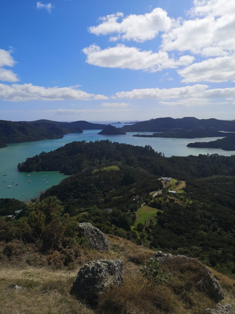
Before long, we were on the road again. Ranj and I had both pinned Whangaroa on our maps as a place to check out. As it was on the way we carried on our way along State Highway 10. Mangroves covered the boundary between land and sea along the natural harbour. We took a moment to try and figure out where the start to the St Paul’s Rock track was. All I had was the summit, which led Ranj to introduce me to Maps.Me, which I found I must have used before as when I installed it, I had maps of Patagonia saved. Ranj took the gravel road half way up the hill. In the heat of the day, I was glad we weren’t going to walk up the whole thing. The views from the top were sublime. Not quite another “oh wow” moment, but we were getting closer. The green-blue water scattered with islands, headlands stretching out as far the bay. The hills again covered with varying shades of green. I’m going to need the thesaurus entry for green before long.

Back to the car and back to the road. There was still another 100km between us and the country’s end. The road straightened out, the land narrowed and dried. Signs appeared on the side of the road pleading for water to be saved where ever possible. The grass dried out further. Turkeys lingered along the road. Abandoned ranch houses. Fields and fields of avocado trees. The world flashing by in greys, browns, blues and erm, greens. Giant sand dunes rose up on the west coast. I found myself feeling like a child on holiday, expecting the final destination to be just over the next hill, or the next one, or the next one. We finally arrived at Tapotutopu camp ground. According to some sources, in order to be able to stay at some of the camp grounds in New Zealand you must first say the place name five times quickly. I would not be staying anywhere. We got the tent up and Ranj put herself down for a nap. I spent the late afternoon watching the waves break over the beach, the clouds race across the sky. Once Ranj was ready, we drove the short distance to Cape Reinga.
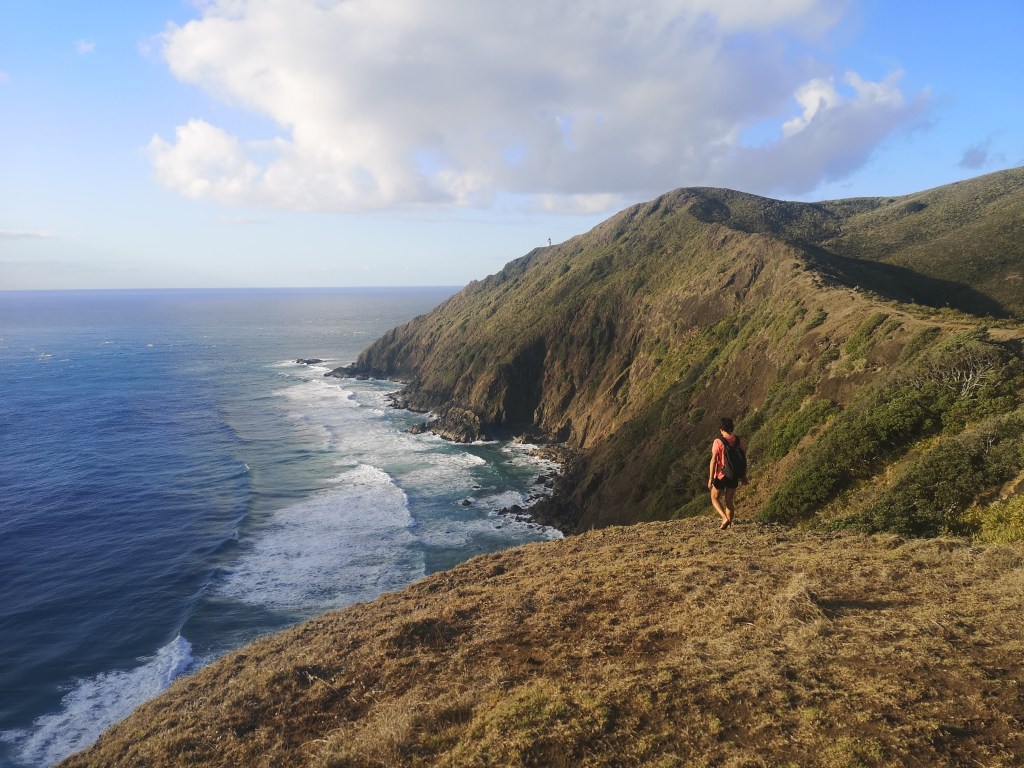
We still had a few hours until sunset, so we explored short stretches of the hiking trails. This was the start of Te Araroa, New Zealand’s end to end walking trail. I had toyed extremely briefly with making this my aim of the trip. To walk the entire length of a country. I talked myself out of it quickly. I’m not fit enough, I’m not experienced enough, I don’t have enough of the right equipment. Maybe it’s true, this isn’t the time for me to find out. We sat on top of the cliffs near the lighthouse, waiting for the sun to go down. I watched the ocean. Green waves rising, wind snatching at the tops pushing the surf back out to sea. The white horses drove towards the coast, leaving a trail of smooth green streamers behind. The break leaves the surface laced with white marble. The next wave leaves another, layer upon layer stretching out to the next headland. The sun dropped below the clouds, the horizon burning gold. Lower still, until it sunk behind the clouds building out to sea. We returned to Tapotutopu for the night. The waves unzipping along the beach combined with the gently falling rain to make this night’s lullaby.

We had reached as far as we could in this direction. The only thing to do was turn back. We stopped on the west coast of the cape to walk on Ninety Mile Beach. A beautiful day without a person in sight. Admittedly it’s midweek and the beach isn’t really easy to get to. People aren’t flocking here. In either direction all I could see was sand dunes, the flat surface of the beach itself, and waves breaking. The horizon was a mix of sea spray and sand. A haze hinting the beach could carry on for eternity. I don’t believe it does, I’m not even convinced it’s a full 90 miles either. We stayed for a while, walking, waiting for the scenery to change. It didn’t. A featureless landscape spectacular in scale. Ranj a vertical line in the distance. I watched seagulls digging out sand dwellers, then running away as waves crept up the beach towards them. The sand bubbling as the water recedes again.

We were on the road once more. Almost the entire length of the country stretched out ahead of us. We only had to make it halfway back to Auckland. By now we’d exhausted the CD collection, were close to running out of stories to share. I could have sat in silence and watched the country pass by but Ranj had another idea. Reaching behind her seat, she pulled out James Patterson’s Along Came A Spider. Having jokingly suggest she read to me on the first night in the tent, I was in trouble now. “Read to me”, she said, “we’re up to chapter two.” I had no choice. I made it through a few chapters before my voice gave in and I was allowed to return to watching the world pass by. Some of the farm houses are modern brick bungalows with shiny black roofs. Others are old wood panels houses painted in pastel greens and yellows with white curtains billowing out of the big open windows. A swamp harrier picking at road kill possum launched into flight as we approached. We round mountains, pass through dense forests and again approach the coast. The sand dunes remain, the water shimmering turquoise under the afternoon sun. As the drive continued, the forests grew denser, human habitation reduced to almost nothing.
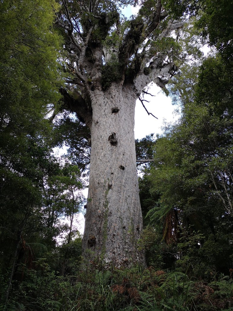
We had arrived in the kauri tree stronghold, at least what remains of it on the west coast. We stopped to visit Tāne Mahuta. Named after the Māori god of forests, the giant is estimated to be around 2000 years old. Some of the jokes that arise when travelling around colonial countries like the U.S., Australia and New Zealand relate to the lack of history. People doing what people do best, overlooking what was there before we were. The surrounding forest was scattered with smaller relatives. Ranj and I remained in the forests, stopping for the night at Trounson Kauri Park. We walked a short loop through the trees, looking up with awe into the canopy, or admiring the moss growth in the understorey. In the visitor’s book there were plenty of notes about kiwi sightings in the night, we talked about venturing out until the rain came in. I was happy to leave the kiwis to do their thing. I awoke to screams in the night, like a child’s cry but less tuneful. Several times I was disturbed by the wailing from the forest. Eventually an orchestra of car alarms, bike bells and other unfamiliar bird song took over. The dawn chorus confirming morning had finally broken and I could reasonably get out of bed. Alongside the notes of kiwi sightings were even more scribbled words about the sounds. The screams in the night were kiwis communicating with their life long partners.

In the morning we headed to one of Ranj’s pins, Kai Iwi lakes. I’d never heard anyone mention them previously. She told me they were renowned for the colour of the water. We drove to the smaller Lake Waikere first. The morning sun glimmering on the surface, turning it to glass. The yellow sands below shone through. Again we had the place to ourselves. After a brief paddle, discovering the water to be warm, I decided to swim. My last two wild swimming adventures were brief, inside the Arctic Circle last July and the Mediterranean in winter. It was unlikely to get better than this, but we continued on to Lake Taharoa to experience the current record for longest “oh wow” yet. Surrounding the lake, pine plantations were sweating in the early heat. Empty hills cleared for pasture rose above, lone trees scattered along the ridge. Cotton wool clouds sprinted across the perfect. Gentle waves bubbling against the shore. A white sand beach with a stretch of shallow, sparkling water that descended into turquoise before dropping into a deep blue. We both enjoyed a casual swim in paradise. A fitting end to our small excursion. All that remained was to return to the relative chaos of Auckland. A reminder, not that further were required, I need to get moving.

Great post 😁
Hey Chris – bringing a tear to my eye as I think of the “old days” when I used to road-trip aroud NZ. You are perversely lucky as there are very few tourists in the country now due to covid virus – it will be a bit more like it used to be about 30-odd years ago.
Get the tissues ready because I’m going to be on the road again as of tomorrow for the foreseeable future! If I can benefit in anyway for the virus situation I’m gonna try and make the most of it, quiet campsites, empty roads, sign me up!
Pingback: New Zealand: The Whangārei Coast | I Don't Have The Map·