I wake up at 5am for some reason. I can’t figure out why, roll over and go back to sleep. When I wake again it’s gone 7am, which is probably too far the other way. Eat, drink coffee, fill all the water containers. Fill the Thermos from the camp kitchen kettle and then get a bloody move on. Rain has fallen three or four times already. This is a fair indicator for how things will proceed for the rest of the day. Time to see some things, do some stuff. After the relentless flats of the Otago and Canterbury coasts, the mountains are a welcome sight. Like shaking the sand out of a towel, the earth whips up into solid black and green peaks stacked on top of each other. At least I have the answer to one of life’s great questions. If I can’t have both then I’ll take the mountains over the sea. Please and thank you. The road snakes and climbs. I don’t remember the last corner that didn’t come with a give way sign. The valley is stripped bare, the exposed ground gives way to the exposed bones of rock beneath. The rounded knuckles of Castle Hill stand black against the grey sky. I’ve had this on my list since lockdown. Another to-do finally ticked off. The conservation area is much bigger than I imagined. Trails run across two hills, up a third and everywhere in between. You could easily lose yourself in the labyrinth of tors for hours. So I do. Leaving the weekend-Christmas-summer holiday crowd behind I go as far away as I can before turning back. The rolling hills and exposed rock brings scenes of Lord of the Rings to my mind. I am shocked and amazed to find not a single scene of the trilogy was filmed here. Something else comes to mind. If Castle Hill is an answer, what is the question not being asked? At first I think it’s the underwhelming Moeraki Boulders, but these aren’t boulders. And it’s quite good. This is a small section of an exposed limestone ridge. The question is the Peak District’s Stanage Edge. Castle Hill answers another Stanage Edge question. How do you take care of the outdoors? A fence is thrown round one outcrop, a protective cloak if you were to read the information board literally. A good idea. We humans don’t need to be everywhere. We can see, touch, walk all over, climb a massive area. The nature reserve, reserved for nature other than us is a small, acceptable sacrifice. I weave back through the towers, the faces, the cauldrons carved into the soft stone. Magic could easily exist in this rock garden. As if to encourage witchcraft, someone (or something) has left a fairy ring in a grass clearing at the centre of a natural amphitheater. I don’t enter the ring, choosing instead to find my way back to the van. I wonder briefly which Arthur the pass is named after. The fairy ring has me in mind of the English Dark Ages, of heroes and wizards. Does one legend of Camelot bring the fabled King around the world? Of course not, the pass was named for Arthur Dobson, the first European to survey the valley. I clearly wasn’t the only person to drift down this avenue. Tucked up away from the road are Mount Lancelot and Mount Guinevere.

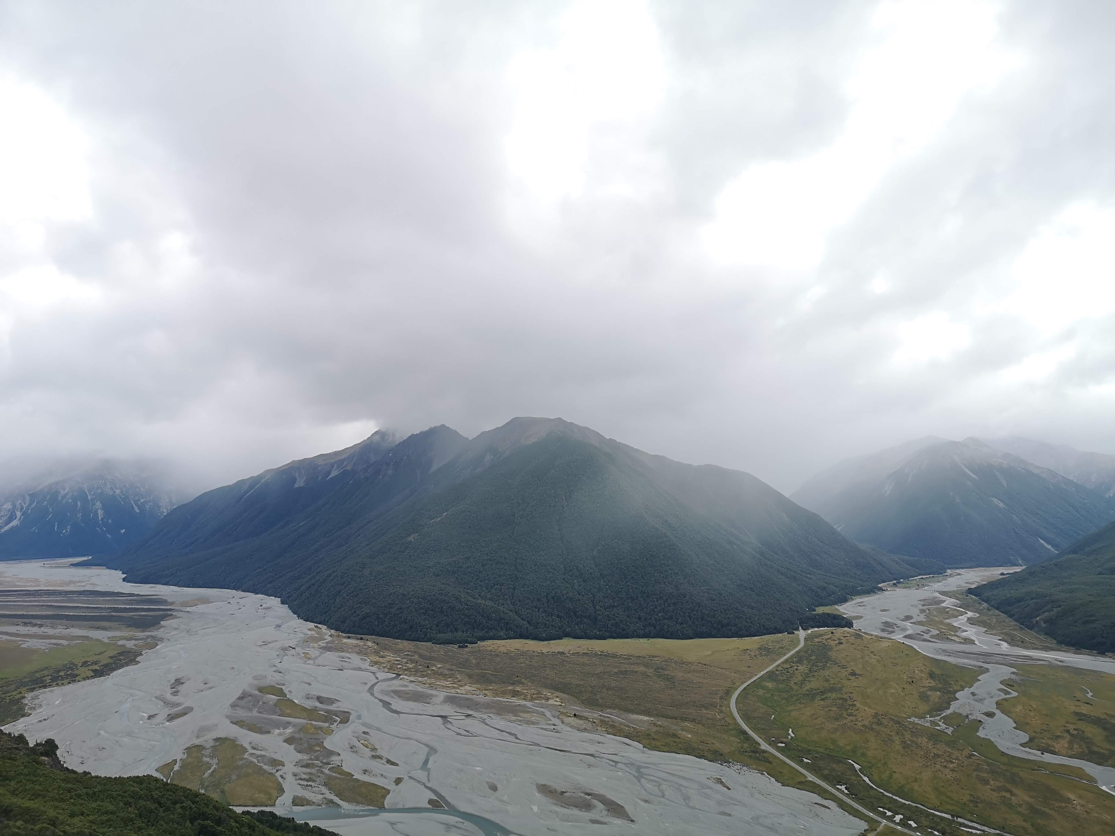
I ride along the road once more. A long straight stretch directly into the belly of the mountains. Clouds are caught on the jagged peaks like sheep’s wool on barbed wire. Other summits are like dunes, black and yellow sand collapsing under the relentless weight of eternity. I cross the braids of the Waimakariri River and park opposite Andrew’s Shelter and watch the sandflies land on the window. Are they like sharks? Do they smell my blood? Can they hear my heart beating? That’s the day over then. No sitting outside in the evening sun. A choice of endless irritation by sandfly or death by carbon monoxide poisoning. I choose death. Not that it ever comes to that. The sandflies struggle with the tiny opening above the window. They’re not so smart. The carbon monoxide knows no such struggle, disappearing into the outside. In the morning I’m cold. I flick the curtains, unsure if I can’t see anything because of condensation or if there’s thick fog in the valley. I stay cocooned in the duvet for a while. I know, I know, every day I say I’ll get up and go and then I don’t. Today I did my best. I got up, ate, drank, got into the front and hoped the engine wasn’t too cold. The van starts and I drive to the village of Arthur’s Pass. Today I am going up something big, maybe the biggest so far. Avalanche Peak. Over 1800m above the sea.

I pack my day bag of layers, food, water and slide my (no longer Iain’s) poles into one of the side pockets. I stop in at the DOC office to make sure I’m not being an idiot. The woman there tells me the weather should be good this morning but a change is coming. “Just don’t dilly-dally,” she says. I take her seriously and move up to the trail head. I find a couple who have clearly not heard the axiom ‘be bold, start cold’, already shedding layers. I smile, say good morning and move ahead of them. They stay behind me a while. I don’t want to rush but one of them doesn’t shut up. All I can hear is a constant droning behind me. Somewhere, they disappear, maybe they turned back. All I know is I’m glad to finally be able to hear the high pitched squeak of the riflemen in the bush. The track climbs up alongside a creek, sometimes the track is the creek. A classic. There are all sorts of people on the trail, wearing all sorts of gear. Mostly sensible footwear, an excellent range of people in every layer to others in almost nothing. Another couple have ripped up behind me, being pulled up by a dog. I’m not entirely sure dogs are supposed to be in the National Park but good on ‘em I guess. Coming free from the bush line I realise I still have a long way to go. Looking back into the valley I can see the saddle that marks the top of Arthur’s Pass. Across is one of the world’s several thousand Devil’s Punchbowl Falls. From here the waterfall resembles one of my favourite kinds, the kind I might stop for. A thin white thread cutting through the hard stone as if it were as soft as cheese.

On the drive in I played a game of I Wonder If That’s Avalanche Peak. None of them were. I haven’t seen the summit. I still can’t now. Crossing the tussock, the track teeters towards the ridge edge. A tiny voice starts to wonder if this was such a good idea. Cloud begins to fill the valley like an inverse bath, from the top down. The summit is fully clagged in. The trail markers lead up into the white out. It would be ok to turn back. Turning back is always ok. The drop down is steep. A real long fall. Don’t think about it. Where’s the next marker pole? Get there. Then the next one. Up on the scree ridge the tiny voice is much louder. We could still turn back. A man coming the other way tells me it’s only another hundred meters to the summit. It’s ok, we’re nearly there. I try to tell the tiny voice this isn’t anywhere near as bad as the Robert Ridge. I don’t know what the problem is. Why is this different? There is no cairn, no trig. There is no more up. The summit still has me in a wobble. I sit down, eat, drink. A few others sit and snack, watching the clouds. They clear briefly in the valley below giving half a view of the Crow River. Now it is time to come down. Down is easier, for once. I’ve already done the route so I know it’s ok. The tiny voice stays quiet. I use the poles above the bush line, taking the pressure off my knees. I move much slower than I have before. People come down from behind, I step aside to let them pass. Below the clouds the views open up again. The sky no longer blue, filled with high white cloud. At the bush line I pack the poles away, confident I can manage the rest of the way. I use tree trunks to control my fall from here and I do manage, all the way to the very bottom where I decide to use my knee instead, opening the skin to let some blood out. At the bottom I cross the road, walk up the opposite track to the viewing platform at the Devil’s 1000th Punchbowl Falls to find out the Maori name is a significant improvement. Hinekakai, which means something like white threads. I can see why.

I returned to Andrew’s Shetler. I parked a little further up the road. Up the hill, around the corner. I’m more exposed. This is good. There’s a wind here which keeps the sandflies at bay. I actually step outside, take a look around. I find a couple taking refuge in the shelter. They’d parked where I had last night. Out of the wind, at the mercy of the sandflies. The forecast change never arrived. These things happen with the weather. As with anything, in the mountains the only certainty is change. All that’s happened by the looks of things is a slight delay of 24 hours. The early morning blues silently shift to grey. I commit to going up to Bealey Hut. Not for the night, but another stretch of the legs. I follow the braids of the Waimakariri River, passing over on a One Lane Bridge. Arthur’s Pass remains magnificent. I don’t regret the choices I’ve made. I only wish I had more time. I want to do everything, but I can’t. Bealey Spur track is a gentle, steady climb through beech forest, over tussock grass. Fledgling fantails dance around my head. This one tree is full of little squeakers. They come to see me, a long time has passed since I last had an entourage. In the deep valley below, the Bruce Stream roars like a motorway. Staring over the precipice my legs turn to jelly. I edge forward on to a protruding boulder. The height isn’t the problem, but the clear and obvious drop. The sudden disappearance of ground beneath my feet. The tiny voice returns to say I am going to fall. I believe it and take a step back. The earth no firmer but further from the edge. I continue along the trail up to a view point. Mountain, valley, river, valley, mountain, valley, road, river, railway line, valley mountain. And all again, at least twice more. Beneath a bleak sky the panorama remains phenomenal. At Bealey Hut I turn around. The summit is the same distance again but I’m not keen for it. I suspect I could manage the distance but my intention is to stay dry.
I empty my bins in Arthur’s Pass village when the rain begins. The view closes in, swallowed by the sky. The mountains always look bigger when you can’t see the tops. Imagination takes over. The forest is spattered with the red blossom of Rata trees. The most I’ve seen on the mainland. I drive past routes and tracks recommended by others. Multi-day trips I’ll now likely never do. There are trampers on the road with their thumb out. Going the other way. Where have they come from I wonder? Where are they going? I wish I was going their way. I hope someone picks them up soon. The green ridges turn to black behind the thin veil of rain. They begin to climb down out of the clouds. Moody, menacing summits slowly soften, levelling out. The rain is now coming town in tanks. A sure sign I’ve arrived back on the West Coast. I returned to Greymouth. The facilities here are good. There is a cold shower and I know I could use one. I make preparations. If I have a cup of tea ready for when I get out that’ll help address the cold. I lie out clean clothes. I step under the shower head and push the button. My expectations are worse than the crash of cold water over my head, my shoulders. I immediately begin to feel better. The rinse is brief, but enough. I change in the toilet, which makes life significantly easier. I even spent time using the hand dryer on my swimming shorts to speed up the drying process. There are times when I really believe I’m nailing this hashtag van life thing. Now I have to figure out what I am going to do with the next 5 days. The forecast is poor for the West Coast. This doesn’t come as a surprise. I decide I’ll take it slow, if things are fair then I’ll get outside. If they’re not, I’ll keep on moving. I should find a hut trip. Somewhere to overnight, to get warmed up for the Gillespie Pass circuit next week.
