Once again I find I have travelled halfway across the North Island in a day. The Central Plateau reminds me of the Scottish Highlands, of the Welsh Mountains. Of something, somewhere, a little closer to home. Grey skies delivering relentless rain. The road North is uphill. Climbs aren’t followed by descents. Poplar trees show yellow leaves. The blanket of grey autumn cloud lies heavy over the land. Gusts of wind push against the van. Rain drops break over the windscreen. Change is coming. I pass through the desert oasis of Waiouru. A single black ridge of Ruapehu disappears into the sky. The weather seems to have gathered at the summit. I feel a longing for the South Island, or maybe just for summer. I continue uphill, to the mountain village of Whakapapa. Old mate Ranj and her partner Josh will arrive at some point. Before I started work I set to making plans to complete the final Great Walks on my list. The Tongariro Northern Circuit and Lake Waikaremoana. Ranj and Josh signed up to join me for the TNC. At the time I was full of confidence, knocking out 20km or more a day comfortably. Of course we can do it in two days I said. The suggested time is three to four days. Now, having had over 6 weeks off trails, I was feeling less confident. The woman in the Department of Conservation visitor centre was optimistic about making the Tongariro Alpine Crossing. One of the most popular day walks in the world. The crossing is the exposed stage of the route, through and around dormant craters. We would be adding an extra day, walking back around the mountains. The forecast is supposed to be improving. One set of weather wizards has the rain running out by tomorrow afternoon. Maybe. Maybe. Maybe. Even the worst case scenarios has us going over the following day, simply in reverse. In my mind, we are crossing the volcanic plateau. This is happening. I will not be stopped.
In the unrelenting rain, I retreat to the Whakapapa Holiday Park. Packing for one night. A hut booked, so no need for the tent. A Great Walk, so no need for a stove. I’ll definitely forget something like my mug, or more likely my toothbrush. Packing comes easy, having ziplock bags and time to pack things down. Will it always be this simple? The supermarkets in the desolate townships lack the basic dried produce I’ve become accustomed to picking up anywhere in the South Island. I’ve got one emergency dehydrated dinner left. The bag is empty, but not light. I replaced the tent with three beers, with berry dusted skinny dipped dark chocolate coated almonds. No power bank, I won’t need to recharge anything after a day. I know I should take my journal, even though I’m unlikely to write anything. I need to reignite the habit. I take a shower, or does the dog cock its leg? A trickle takes minutes to show any signs of warming up. Already the luxury of living at Iain and Charlotte’s has rubbed off on me. Left me soft. Hot water on demand, fierce pressure, a removable shower head. I begin to recognise there are different degrees of clean. This at least has warmed enough to stand under and scrub. Better than the cold showers around the coast. Better than the glacial rivers and lakes. Not better than a privately owned shower in the en-suite of a guest bedroom in the suburbs of Wellington. This is an easing back in to full time van life. A period I hope to break sooner than the last. Even if the van remains for sleeping. I need to spend less time on the move, less money on fuel. I was sitting in the camp kitchen over-thinking, killing time when I hear “hello mate, how are you?” Ranj and Josh have snuck in without me noticing.

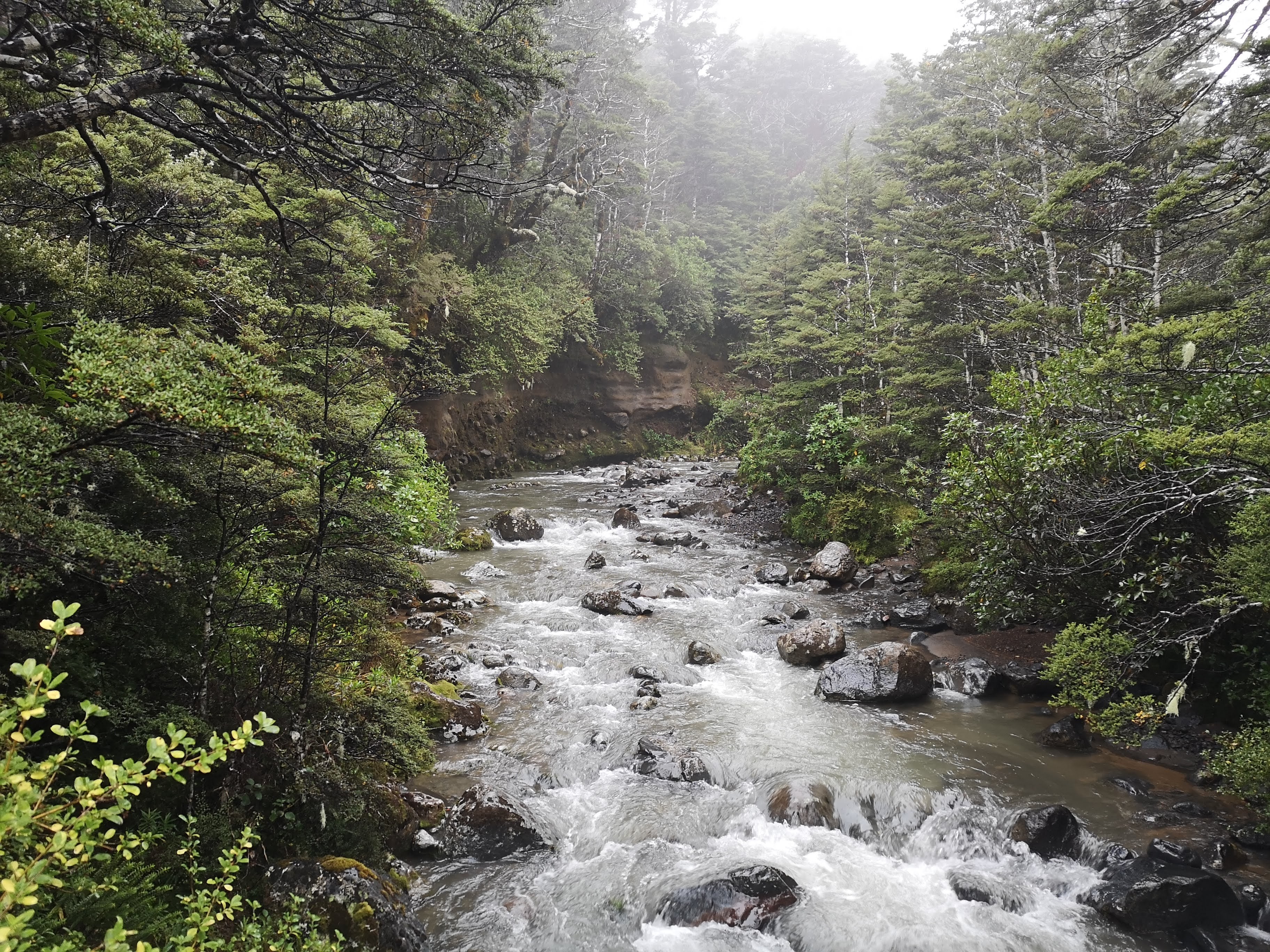
Through the night rain hammers down on the roof of the van. If it isn’t raining, the water left in the trees drops without rhythm. When I wake up I emerge to find a wet, misty morning.We can’t get up and go. Josh needs to wait for the visitor centre to open so he can get an overnight parking permit for his car. We won’t be hitting the trail until just after 8am at the earliest. This is probably no bad thing. The clag lays heavy over the surrounding landscape, there’s nothing to see here. Not yet. We walk off the road, on to the track. We’re going on an adventure! Rain comes and goes, a fine spray coating waterproofs. Does water have to fall to count as rain? We’re getting wet by walking through the clouds. “It’s good to be out,” I say to anyone who is listening. I believe it too, despite the weather. Dark shapes linger in the gloom, shadows of ridge lines and hillsides. We follow the heavily eroded trail through stream beds. A roar ahead suggests a river. “That sounds like it will have a bridge,” I state with the confidence of a man who has done this sort of thing before. Josh, who is on his first Great Walk, seems impressed with my knowledge. I am lucky to find there is a bridge in the valley and we avoid getting our feet wet. There is still not much to see. An ancient cone fades into view behind the grey curtain of rain. As we move towards the peak, another wall of rock begins to emerge. We’re approaching the valley of the Mangatepopo stream, where we join the track for the Tongariro Alpine Crossing. We take a break at the Mangatepopo Hut. Had we gone for the slow option, this would be our stop for the first night. Day one finished in time for morning tea. This was one of the reasons I decided we should skip it. There would be enough time, we would have enough energy to keep going on to the next hut some 13km on from here. Not long after we arrive a tired, wet French woman arrives. She has come over the crossing from Oturere Hut, our destination. It’s taken her four hours. “How was it up there?” I asked. “Shit,” she replied “I saw nothing but rain.” We laugh. The cloud still lays thick over the land, though it’s swirling faster now. The bright white of the sun is visible behind the veil. Things could still improve. After a cup of tea and a handful of snacks I indicate to Ranj and Josh we should probably get moving. Lava bluffs invisible on our arrival have come out to see us. We pass across old flows, the once red hot liquid rock now solid black.

We come to the first warning sign. This one is specifically about the weather. Two photos of the entrance to the Southern Crater. One is backed by blue sky, the mountains clear and visible. The other, only the lowest rocks can be seen. Looking up at the landscape we witness a scene somewhere between the two. “That’s good enough for me,” I tell the team. They’re in agreement. We are going over the top. The clouds continue to lift as we approach the Devil’s Staircase. A large group have taken seats on boulders at the bottom of the stairs. This is a good idea. From memory, when I was last here the Devil’s Staircase was the worst part. I remember legs feeling like stone, making hard work of the near endless climb. We don’t stop for long. We begin our climb. The stairs make short work of the ascent. Things are going well, certainly not as bad as I remember. There’s another person up ahead wearing fluorescent orange. Only when I notice they’re not moving do I realise it’s another warning sign. The person cut out of cardboard, holding up a hand. A reminder, it’s never too late to turn back. I stop and look back down the valley. The large group have become tiny ants on the march, crawling along the edge of the Mangatepopo valley. Nobody is following us. The questionable forecast must have put people off. We arrive on the edge of the Southern Crater. Down in the valley below blue sky lies beyond the cloud. Light from the sun lands on dark forests and bright fields. The higher clouds swirl around the surrounding peaks. Ngauruhoe remains shrouded. The jagged summits of Mount Tongariro come and go with the wind. There’s nobody moving in the flat bottom of the dead volcano. There’s no sign of any movement coming up the Devil’s Staircase. We are out here alone. Come on now hobbits. Time to go. The flat plain of the Southern Crater is easy walking. Up ahead another burst up over the outer rim to the track’s high point; the Red Crater. The sun glows gold through the clouds. White tendrils whisp down, clutching at the rocks before being the wind catches them, blowing them beyond the mountain. The last climb is challenging. I remember a chain here before, now there is nothing. Only the slippery wet clay, the loose scree. Each step is careful. Gusts slam into us from the side. The clouds look as though they’re about to close in again. We reach the edge of the Red Crater.

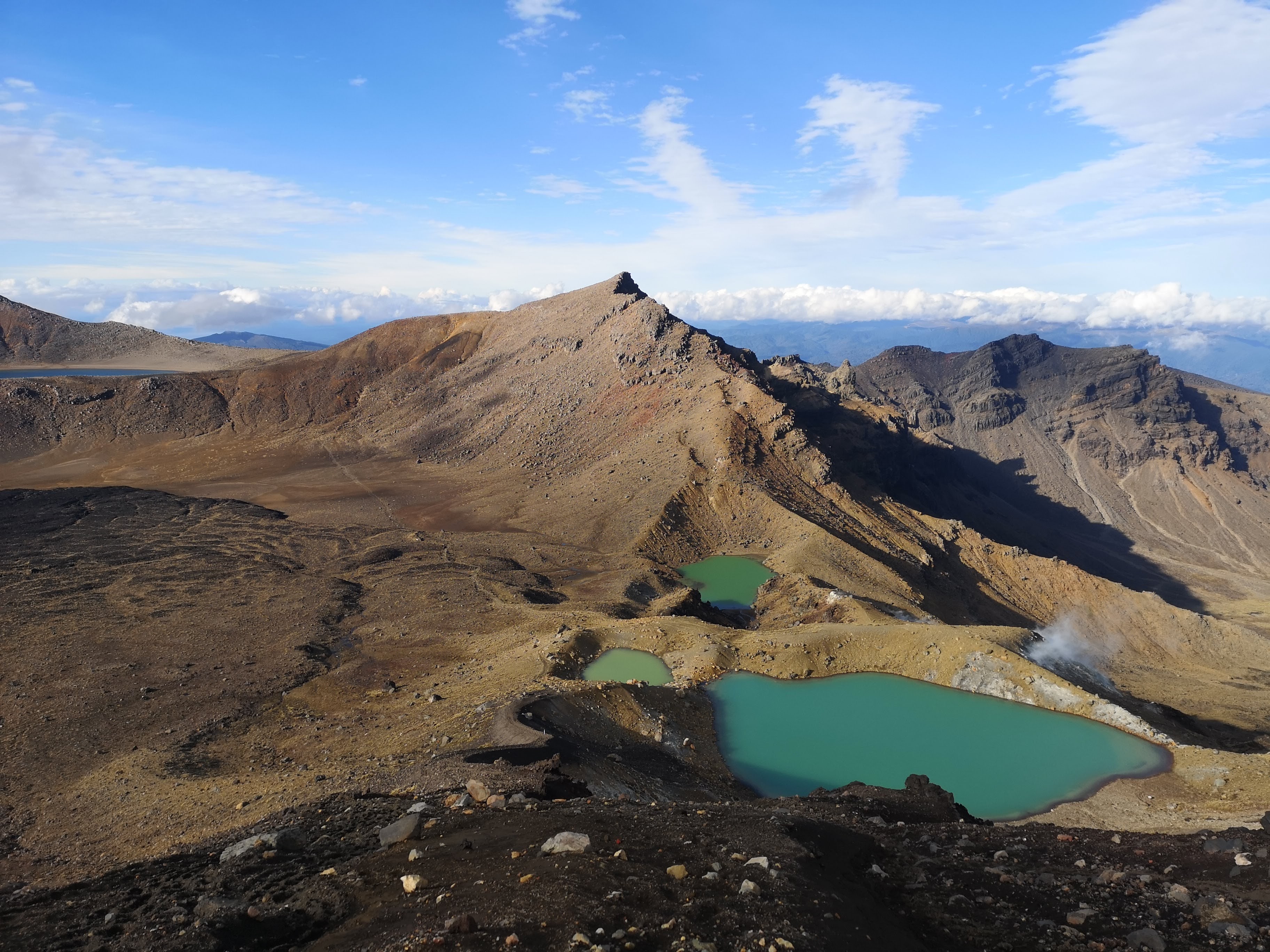
Blue skies open above us. Vibrant red rocks dust lines the ash and scoria. Beyond the volcano, a view expands down the Oturere Valley out to the Kaimanawa Ranges. A long white cloud hangs above those distant mountains. Behind us Ngauruhoe’s summit emerges just for a second. Just a glimpse was all I needed. A pile of pumice has built up at highest point on the crossing. How far people have carried these rocks to place here is anyone’s guess. From the beginning? From the Southern Crater? We don’t add anything. From the top the Emerald Lakes come in to view. We can see! We can see everything. Further distant, Blue Lake shimmers in a crater of its own. More amazing to me, shocking almost, is there is nobody else here. There isn’t a stampede of tourists. No chain of people lining up to take their own photographs. Ranj, Josh and I have the entire Tongariro Alpine Crossing to ourselves and the conditions could hardly be better. And then comes trouble. The down. A mixture of packed, steep scree and ash like sand. A blast of lightening strikes upwards from my right knee. No. No. No. Not like this. Not now. While there have been moments of trouble in the South Island, I’ve not felt anything like this since the first time. Why now? What is different? Was it too much distance? Too big a climb? I hadn’t warmed up. Or maybe it’s something else, maybe I’m dehydrated. I don’t know. I let Ranj and Josh pass me by. “I’ll see you at the bottom.” The poles save me, I take the weight off. I slow down, taking my time. I’m still moving, still smiling. I will get through this.
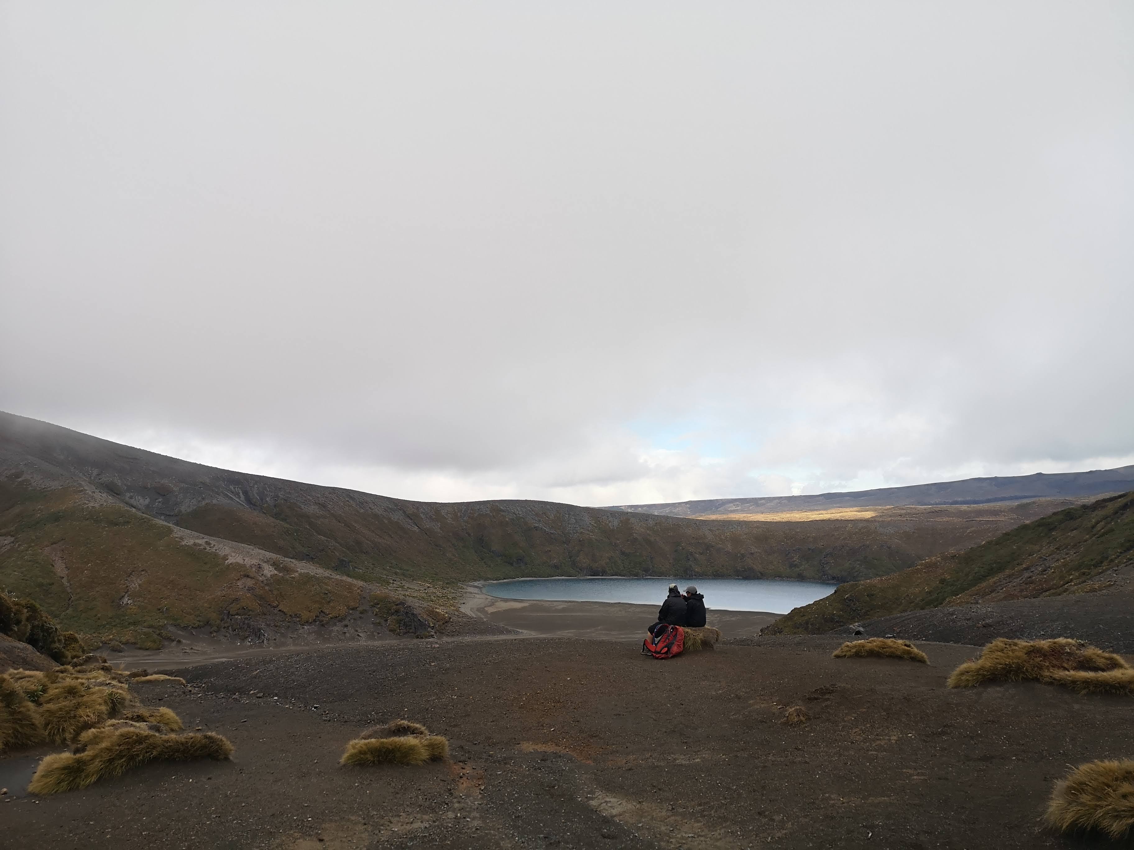
From the Emerald Lakes our route takes us away from the Tongariro Alpine Crossing. Instead of descending to the Ketehai Car Park, we take a right towards the Oturere Valley. Another steep descent takes us out through a near lifeless environment of jagged lava forms. The only thing I can think of is this looks like the moon, which is strange because I have never been to the moon. I suppose if not the moon, from here the Tongariro National Park really does look like Mordor. Down in the valley below, Ranj and Josh scurry between boulders. I feel like I should be leading my two little hobbits, wearing red Macpac waterproof bag covers instead of elven cloaks. Behind us, Ngauruhoe has fully emerged from the clouds. This is the Mount Doom angle. More distant still, the broken glass summit of Mount Ruapehu joins the view. The remaining clouds begin to glow gold in the slow dying light of the day. As the track flattens out I begin to pick up my speed again, catching up with Ranj and Josh. We make the final approach to Oturere Hut together. Blue markers count down the distance. The final 1km is always the longest. Then, tucked in to the valley’s side is a the small Oturere Hut. I thought we might have a quiet night but dotted across the slopes are bright colours of people in down jackets and fleeces. The sky over the Kaimanawa Ranges has put on the full light show. Blues to purples, purples to pinks, yellows to orange. We pass in as the last, late arrivals. One woman looks at us, “Please don’t tell me you’ve come over from Whakapapa today.” “Okay, I won’t tell you.” She had decided to come around the back, waiting until tomorrow to complete the crossing when the weather is supposed to be better. We got very, very lucky.
I slip in to a bunk against the wall, in the main room. No matter who gets up first, I’ll be awake. Oturere Hut is a pokey little hut, not like those on the other Great Walks. There are only two stoves and one sink for the 26 bunks. Good thing it’s only half full. There are other similarities. Warden Tom comes in to give his version of the “don’t burn the place to the ground, don’t leave it in a mess” hut talk. It’s not bad. He sticks around to talk and shatters one of my illusions.In my six months of tramping the backcountry of New Zealand, I, along with others concluded that there are no dickheads on the trail. Warden Tom tells us a few weeks ago someone completed the Round the Mountain track, while they did so they deliberately turned all the taps on in each hut they stayed in, draining the water for all subsequent visitors. Not cool. Warden Tom tells us to make sure we make the side trip to Ohinepango Springs, and on our way out to reach at least the Lower Tama lake. I take time out to check on other people’s dining habits. Too many people are still choosing to eat Backcountry Cuisine dehydrated meals. I talk passionately with them about how much better Radix meals are and wonder what I need to do to be put on commission. The solar lights come on, but not for long. People quickly retire to bed. After our big day, I’m delighted to do the same.
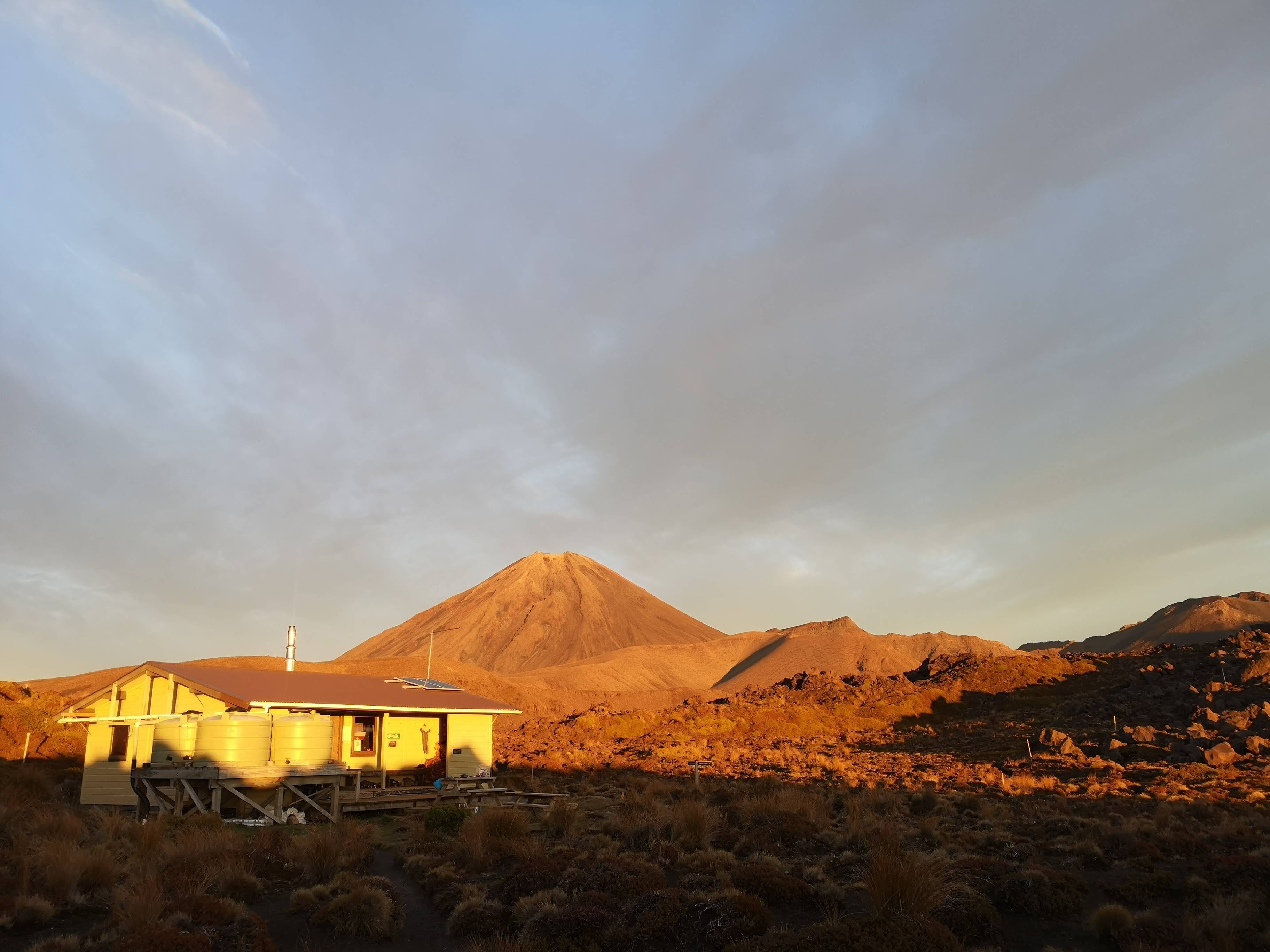
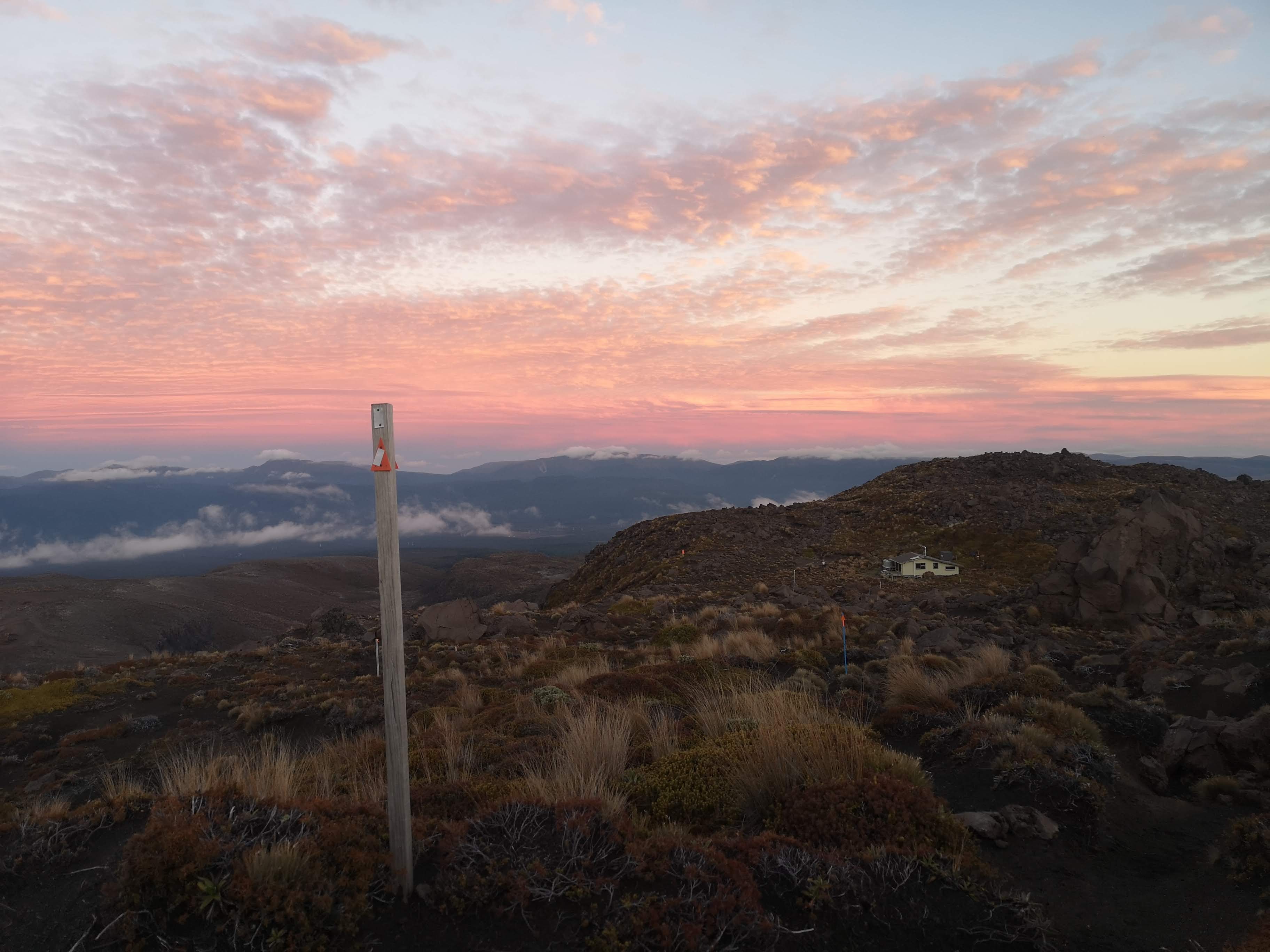
People are on the move early. I get up in the dark and head out to the toilet. First light is breaking over the clear peaks of Ngauruhoe and Ruapehu. For those making the crossing today, they’d do well to get up there soon. We’re not rushing, but we’re not hanging about either. While we don’t need as favourable weather, we’ve still got another big walk ahead of us. We eat, pack, and ready to leave. Our journey takes us in the direction of Ruapehu. Across gravel fields, through dry stream beds. There is almost no life here. A few patches of tussock grass. In the distance are pockets of beech forest. Areas that until now have somehow remained unaffected by relentless eruptions. We make our way towards one of these woodlands. On a nearby ridge, where I’m sure our path leads I can see people. Taking one of my poles as a pointer, I aim. “I think there are people up there on that ridge,” I tell the team. “They must be coming this way from Waihohonu Hut.” Nobody seems convinced. The trail markers lead away from the ridge, down in to another valley. This one with a stream in. Closer now I can see what I thought were people are nothing more than rocks and trees, unmoving and off the path. The small pocket of bush provides the last push to Waihohonu Hut. Compared to Oturere, Waihohonu is like a palace. There’s bunk rooms in each wing, with a communal area big enough to fit the entirety of Oturere Hut within. Warden Sam comes out to see what we’re about. I realise if I was more organised I could have kept walking from Oturere Hut straight on past Waihohonu Hut and round Ruapehu. Ditching my pals for a longer trek. Remembering instead, all of the hobbling, limping and wincing I’ve done down hill, better to keep it real, stick together. I mention my interest in going Round the Mountain to Warden Sam, as I’ll have to come back and spend the night. He thinks I’ll have no trouble in getting a booking. He also points out a potential shortcut to skip the Ohakune Road. I’ll hold on to this useful information.

We hit the trail again, one more time. A final push up over the Tama Saddle. We reach a high point on the trail, at least I think it’s the high point. “I think this is the Tama Saddle,” I say to Josh. “All downhill from here.” Of course I don’t actually know. I know the hill to our right is Tama, somewhere nearby are the lakes and the trail doesn’t look like it’s going up anymore. Then we continue on up. “I don’t think I know what I’m talking about,” I say to Josh. He agrees. We climb way beyond the point I thought was the saddle. “I think we’ll be able to see the Lower Tama lake soon,” says Josh. “Are you sure?” I ask. I’m convinced the turn off would be visible if the lakes were. In the next clearing, down a small gully is a black sand beach and a body of water. Josh has clearly been paying more attention to his map than me. It still takes us a while to reach the turn off for the lakes. Lower Tama is 10 minutes. Upper Tama is 45 minutes and we can see the hill we need to climb. I might get up, but there’s no way I’d get back down again. Fortunately, Ranj and Josh are in agreement. We’ve bitten off more than we can walk, adding any more would be silly. So we only go as far as Lower Tama. I’m surprised at how small the lake is. Most of the crater is filled with sand. We pause for a lunch break. The wind picks up, I can feel the damp of rain being blown across the saddle. Time to go.
The clouds close in. Views are erased. We’re set to finish as we started. We roll up and down hills. I slow down on the downs, and try to catch up again on the flats and the ups. For a time this works, but then I drop further and further behind. I come down flights of stairs like someone twice my ages. One step at a time, favouring my strong leg. We must be getting close. The scenery looks familiar, we haven’t walked this way but everything looks the same. We come to the final junction, Taranaki Falls awaits in the valley below. More of the same rides across the tussock hills above. The choice is obvious. Down we go. I despair at the sight of the staircase that drops into the Wairere Stream valley. Ranj and Josh are out of sight by the time I reach the bottom. Up ahead I can hear screaming. It doesn’t sound like my friends. I get to the falls to see two women half in the plunge pool below the falls. Good on them. I’m sure the cold water shock would be good for my joints but the shock of cold doesn’t sound appealing in any other way. I catch up with Ranj and Josh and we make the final approach to Whakapapa. We climb out of the valley, there ahead of us is the Chateau Tongariro. Behind me I can hear Ranj laughing. “Look at the state of you,” she says. What could possibly be funny? Josh is waddling. I’m dragging my right foot. We’re invalids. The Tongariro Northern Circuit broke us and Ranj finds this undeniably hilarious. We tramp across the front grounds of the Chateau, back to the cars. We check in again at the Whakapapa Holiday Park. There’s time for showers, then it’s time to get down to the village of National Park for some well deserved food and drinks.
